Address: 898 (From 898 To 1198 Even) WARTRACE HWY, PLEASANT SHADE, TN 37145-6031, USA
What's 37145-6031? 37145-6031 is a ZIP Code 5 Plus 4 number of 898 (From 898 To 1198 Even) WARTRACE HWY, PLEASANT SHADE, TN, USA. Below is detail information.
37145-6031 Basic Information

-
ZIP Code 5 Plus 4:
37145-6031 -
ZIP Code 5:
37145 -
Plus 4?60314-digits that are used to identify a geographic segment within the 5-digit delivery area, such as a city block or a group of apartments or an individual high-volume receiver of mail, or any other unit that could use an extra identifier to aid in efficient mail sorting and delivery. This code is the low end of the range of +4 Codes that pertain to this ZIP Code. ZIP+4 Codes associated with nondelivery areas are composed of valid ZIP sector numbers and "ND" for the ZIP segment number, for example 12345-12ND. Non-deliverable areas are areas to which the USPS does not deliver mail, such as vacant lots and land that borders railroad tracks. Mailers should not match an address identified as a nondelivery area. If you absolutely must have numeric characters in the Plus4Code column, you may treat "ND" values as "00" (zero zero).:
-
Country:
U.S. - United States -
State:
TN - Tennessee -
County:
CountyFIPS: 47087 - Jackson County -
City:
PLEASANT SHADE -
Street?WARTRACE HWYThe official name of a street as assigned by a local governing authority. The Street Name column contains only the street name and does not include directionals (EAST, WEST, etc.) or suffixes (ST, DR, BLVD, etc.). This element may also contain literals, such as PO BOX, GENERAL DELIVERY, USS, PSC, or UNIT. Numeric street names that have numeric components that are four characters (or less) in length at are justified such that the low-order digit of the number is positioned in the fourth position of the street name column. This shift is made so that the numeric street names appear in numeric sequence.:
-
Street Suffix?HWYThe street suffix: For Example: ST = Street RD = Road DR = Drive LN = Lane:
-
Record Type?S: StreetAn alphabetic value that identifies the type of data in the record. Record type codes include the following: G = General delivery H = Highrise F = Firm S = Street P = PO box R = Rural route/highway contract:
Address

- Address Primary Low Number?
A house, rural route, highway contract box, or post office box number; the numeric or alphanumeric component of an address preceding the street name; the low-end address in a range of addresses. Often referred to as house number.: 898
- Address Primary High Number?
A house, rural route, contract box, or Post Office box number. The numeric or alphanumeric component of an address preceding the street name. The high-end address in a range of addresses. Often referred to as house number.: 1198
- Address Primary Odd / Even Code?
Code that identifies the side or sides of a street for which a given address range is applicable. For street, highrise, firm and multi-carrier records, B = Both sides of a street, E = Even side of a street (even-numbered addresses in the range); O = Odd side of a street (odd-numbered addresses in the range). For general delivery, post office box, and rural route/highway contract records, this code will always be "B" (both).: Even
- Primary Range: 898, 900, 902, 904, 906, 908, 910, 912, 914, 916, 918, 920, 922, 924, 926, 928, 930, 932, 934, 936, 938, 940, 942, 944, 946, 948, 950, 952, 954, 956, 958, 960, 962, 964, 966, 968, 970, 972, 974, 976, 978, 980, 982, 984, 986, 988, 990, 992, 994, 996, 998, 1000, 1002, 1004, 1006, 1008, 1010, 1012, 1014, 1016, 1018, 1020, 1022, 1024, 1026, 1028, 1030, 1032, 1034, 1036, 1038, 1040, 1042, 1044, 1046, 1048, 1050, 1052, 1054, 1056, 1058, 1060, 1062, 1064, 1066, 1068, 1070, 1072, 1074, 1076, 1078, 1080, 1082, 1084, 1086, 1088, 1090, 1092, 1094, 1096, 1098, 1100, 1102, 1104, 1106, 1108, 1110, 1112, 1114, 1116, 1118, 1120, 1122, 1124, 1126, 1128, 1130, 1132, 1134, 1136, 1138, 1140, 1142, 1144, 1146, 1148, 1150, 1152, 1154, 1156, 1158, 1160, 1162, 1164, 1166, 1168, 1170, 1172, 1174, 1176, 1178, 1180, 1182, 1184, 1186, 1188, 1190, 1192, 1194, 1196, 1198.
Please click the "More Address Examples" to view the whole list.
898 WARTRACE HWY, PLEASANT SHADE, TN 37145-6031
900 WARTRACE HWY, PLEASANT SHADE, TN 37145-6031
902 WARTRACE HWY, PLEASANT SHADE, TN 37145-6031
904 WARTRACE HWY, PLEASANT SHADE, TN 37145-6031
906 WARTRACE HWY, PLEASANT SHADE, TN 37145-6031
908 WARTRACE HWY, PLEASANT SHADE, TN 37145-6031
910 WARTRACE HWY, PLEASANT SHADE, TN 37145-6031
912 WARTRACE HWY, PLEASANT SHADE, TN 37145-6031
914 WARTRACE HWY, PLEASANT SHADE, TN 37145-6031
916 WARTRACE HWY, PLEASANT SHADE, TN 37145-6031
918 WARTRACE HWY, PLEASANT SHADE, TN 37145-6031
920 WARTRACE HWY, PLEASANT SHADE, TN 37145-6031
922 WARTRACE HWY, PLEASANT SHADE, TN 37145-6031
924 WARTRACE HWY, PLEASANT SHADE, TN 37145-6031
926 WARTRACE HWY, PLEASANT SHADE, TN 37145-6031
928 WARTRACE HWY, PLEASANT SHADE, TN 37145-6031
930 WARTRACE HWY, PLEASANT SHADE, TN 37145-6031
932 WARTRACE HWY, PLEASANT SHADE, TN 37145-6031
934 WARTRACE HWY, PLEASANT SHADE, TN 37145-6031
936 WARTRACE HWY, PLEASANT SHADE, TN 37145-6031
938 WARTRACE HWY, PLEASANT SHADE, TN 37145-6031
940 WARTRACE HWY, PLEASANT SHADE, TN 37145-6031
942 WARTRACE HWY, PLEASANT SHADE, TN 37145-6031
944 WARTRACE HWY, PLEASANT SHADE, TN 37145-6031
946 WARTRACE HWY, PLEASANT SHADE, TN 37145-6031
948 WARTRACE HWY, PLEASANT SHADE, TN 37145-6031
950 WARTRACE HWY, PLEASANT SHADE, TN 37145-6031
952 WARTRACE HWY, PLEASANT SHADE, TN 37145-6031
954 WARTRACE HWY, PLEASANT SHADE, TN 37145-6031
956 WARTRACE HWY, PLEASANT SHADE, TN 37145-6031
958 WARTRACE HWY, PLEASANT SHADE, TN 37145-6031
960 WARTRACE HWY, PLEASANT SHADE, TN 37145-6031
962 WARTRACE HWY, PLEASANT SHADE, TN 37145-6031
964 WARTRACE HWY, PLEASANT SHADE, TN 37145-6031
966 WARTRACE HWY, PLEASANT SHADE, TN 37145-6031
968 WARTRACE HWY, PLEASANT SHADE, TN 37145-6031
970 WARTRACE HWY, PLEASANT SHADE, TN 37145-6031
972 WARTRACE HWY, PLEASANT SHADE, TN 37145-6031
974 WARTRACE HWY, PLEASANT SHADE, TN 37145-6031
976 WARTRACE HWY, PLEASANT SHADE, TN 37145-6031
978 WARTRACE HWY, PLEASANT SHADE, TN 37145-6031
980 WARTRACE HWY, PLEASANT SHADE, TN 37145-6031
982 WARTRACE HWY, PLEASANT SHADE, TN 37145-6031
984 WARTRACE HWY, PLEASANT SHADE, TN 37145-6031
986 WARTRACE HWY, PLEASANT SHADE, TN 37145-6031
988 WARTRACE HWY, PLEASANT SHADE, TN 37145-6031
990 WARTRACE HWY, PLEASANT SHADE, TN 37145-6031
992 WARTRACE HWY, PLEASANT SHADE, TN 37145-6031
994 WARTRACE HWY, PLEASANT SHADE, TN 37145-6031
996 WARTRACE HWY, PLEASANT SHADE, TN 37145-6031
998 WARTRACE HWY, PLEASANT SHADE, TN 37145-6031
1000 WARTRACE HWY, PLEASANT SHADE, TN 37145-6031
1002 WARTRACE HWY, PLEASANT SHADE, TN 37145-6031
1004 WARTRACE HWY, PLEASANT SHADE, TN 37145-6031
1006 WARTRACE HWY, PLEASANT SHADE, TN 37145-6031
1008 WARTRACE HWY, PLEASANT SHADE, TN 37145-6031
1010 WARTRACE HWY, PLEASANT SHADE, TN 37145-6031
1012 WARTRACE HWY, PLEASANT SHADE, TN 37145-6031
1014 WARTRACE HWY, PLEASANT SHADE, TN 37145-6031
1016 WARTRACE HWY, PLEASANT SHADE, TN 37145-6031
1018 WARTRACE HWY, PLEASANT SHADE, TN 37145-6031
1020 WARTRACE HWY, PLEASANT SHADE, TN 37145-6031
1022 WARTRACE HWY, PLEASANT SHADE, TN 37145-6031
1024 WARTRACE HWY, PLEASANT SHADE, TN 37145-6031
1026 WARTRACE HWY, PLEASANT SHADE, TN 37145-6031
1028 WARTRACE HWY, PLEASANT SHADE, TN 37145-6031
1030 WARTRACE HWY, PLEASANT SHADE, TN 37145-6031
1032 WARTRACE HWY, PLEASANT SHADE, TN 37145-6031
1034 WARTRACE HWY, PLEASANT SHADE, TN 37145-6031
1036 WARTRACE HWY, PLEASANT SHADE, TN 37145-6031
1038 WARTRACE HWY, PLEASANT SHADE, TN 37145-6031
1040 WARTRACE HWY, PLEASANT SHADE, TN 37145-6031
1042 WARTRACE HWY, PLEASANT SHADE, TN 37145-6031
1044 WARTRACE HWY, PLEASANT SHADE, TN 37145-6031
1046 WARTRACE HWY, PLEASANT SHADE, TN 37145-6031
1048 WARTRACE HWY, PLEASANT SHADE, TN 37145-6031
1050 WARTRACE HWY, PLEASANT SHADE, TN 37145-6031
1052 WARTRACE HWY, PLEASANT SHADE, TN 37145-6031
1054 WARTRACE HWY, PLEASANT SHADE, TN 37145-6031
1056 WARTRACE HWY, PLEASANT SHADE, TN 37145-6031
1058 WARTRACE HWY, PLEASANT SHADE, TN 37145-6031
1060 WARTRACE HWY, PLEASANT SHADE, TN 37145-6031
1062 WARTRACE HWY, PLEASANT SHADE, TN 37145-6031
1064 WARTRACE HWY, PLEASANT SHADE, TN 37145-6031
1066 WARTRACE HWY, PLEASANT SHADE, TN 37145-6031
1068 WARTRACE HWY, PLEASANT SHADE, TN 37145-6031
1070 WARTRACE HWY, PLEASANT SHADE, TN 37145-6031
1072 WARTRACE HWY, PLEASANT SHADE, TN 37145-6031
1074 WARTRACE HWY, PLEASANT SHADE, TN 37145-6031
1076 WARTRACE HWY, PLEASANT SHADE, TN 37145-6031
1078 WARTRACE HWY, PLEASANT SHADE, TN 37145-6031
1080 WARTRACE HWY, PLEASANT SHADE, TN 37145-6031
1082 WARTRACE HWY, PLEASANT SHADE, TN 37145-6031
1084 WARTRACE HWY, PLEASANT SHADE, TN 37145-6031
1086 WARTRACE HWY, PLEASANT SHADE, TN 37145-6031
1088 WARTRACE HWY, PLEASANT SHADE, TN 37145-6031
1090 WARTRACE HWY, PLEASANT SHADE, TN 37145-6031
1092 WARTRACE HWY, PLEASANT SHADE, TN 37145-6031
1094 WARTRACE HWY, PLEASANT SHADE, TN 37145-6031
1096 WARTRACE HWY, PLEASANT SHADE, TN 37145-6031
1098 WARTRACE HWY, PLEASANT SHADE, TN 37145-6031
1100 WARTRACE HWY, PLEASANT SHADE, TN 37145-6031
1102 WARTRACE HWY, PLEASANT SHADE, TN 37145-6031
1104 WARTRACE HWY, PLEASANT SHADE, TN 37145-6031
1106 WARTRACE HWY, PLEASANT SHADE, TN 37145-6031
1108 WARTRACE HWY, PLEASANT SHADE, TN 37145-6031
1110 WARTRACE HWY, PLEASANT SHADE, TN 37145-6031
1112 WARTRACE HWY, PLEASANT SHADE, TN 37145-6031
1114 WARTRACE HWY, PLEASANT SHADE, TN 37145-6031
1116 WARTRACE HWY, PLEASANT SHADE, TN 37145-6031
1118 WARTRACE HWY, PLEASANT SHADE, TN 37145-6031
1120 WARTRACE HWY, PLEASANT SHADE, TN 37145-6031
1122 WARTRACE HWY, PLEASANT SHADE, TN 37145-6031
1124 WARTRACE HWY, PLEASANT SHADE, TN 37145-6031
1126 WARTRACE HWY, PLEASANT SHADE, TN 37145-6031
1128 WARTRACE HWY, PLEASANT SHADE, TN 37145-6031
1130 WARTRACE HWY, PLEASANT SHADE, TN 37145-6031
1132 WARTRACE HWY, PLEASANT SHADE, TN 37145-6031
1134 WARTRACE HWY, PLEASANT SHADE, TN 37145-6031
1136 WARTRACE HWY, PLEASANT SHADE, TN 37145-6031
1138 WARTRACE HWY, PLEASANT SHADE, TN 37145-6031
1140 WARTRACE HWY, PLEASANT SHADE, TN 37145-6031
1142 WARTRACE HWY, PLEASANT SHADE, TN 37145-6031
1144 WARTRACE HWY, PLEASANT SHADE, TN 37145-6031
1146 WARTRACE HWY, PLEASANT SHADE, TN 37145-6031
1148 WARTRACE HWY, PLEASANT SHADE, TN 37145-6031
1150 WARTRACE HWY, PLEASANT SHADE, TN 37145-6031
1152 WARTRACE HWY, PLEASANT SHADE, TN 37145-6031
1154 WARTRACE HWY, PLEASANT SHADE, TN 37145-6031
1156 WARTRACE HWY, PLEASANT SHADE, TN 37145-6031
1158 WARTRACE HWY, PLEASANT SHADE, TN 37145-6031
1160 WARTRACE HWY, PLEASANT SHADE, TN 37145-6031
1162 WARTRACE HWY, PLEASANT SHADE, TN 37145-6031
1164 WARTRACE HWY, PLEASANT SHADE, TN 37145-6031
1166 WARTRACE HWY, PLEASANT SHADE, TN 37145-6031
1168 WARTRACE HWY, PLEASANT SHADE, TN 37145-6031
1170 WARTRACE HWY, PLEASANT SHADE, TN 37145-6031
1172 WARTRACE HWY, PLEASANT SHADE, TN 37145-6031
1174 WARTRACE HWY, PLEASANT SHADE, TN 37145-6031
1176 WARTRACE HWY, PLEASANT SHADE, TN 37145-6031
1178 WARTRACE HWY, PLEASANT SHADE, TN 37145-6031
1180 WARTRACE HWY, PLEASANT SHADE, TN 37145-6031
1182 WARTRACE HWY, PLEASANT SHADE, TN 37145-6031
1184 WARTRACE HWY, PLEASANT SHADE, TN 37145-6031
1186 WARTRACE HWY, PLEASANT SHADE, TN 37145-6031
1188 WARTRACE HWY, PLEASANT SHADE, TN 37145-6031
1190 WARTRACE HWY, PLEASANT SHADE, TN 37145-6031
1192 WARTRACE HWY, PLEASANT SHADE, TN 37145-6031
1194 WARTRACE HWY, PLEASANT SHADE, TN 37145-6031
1196 WARTRACE HWY, PLEASANT SHADE, TN 37145-6031
1198 WARTRACE HWY, PLEASANT SHADE, TN 37145-6031
Address Example
PLEASANT SHADE TN 37145-6031
UNITED STATES OF AMERICA
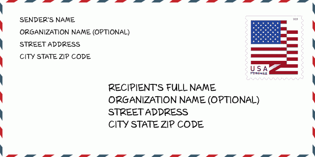
37145-6031 Envelope Example

-
This is an example of U.S envelope. Fill in the sender's information at the top left and the recipient information at the bottom right. The necessary information is sender/recipient's full name, street address, city, state and zip code. The recipient address information has been given for your reference. Generally, If you are not sure of the full 9-digit zip code, you can only fill in the 5-digit zip code to avoid loss of package.
37145-6031 Basic Meaning
-
What does each digit of ZIP Code 37145-6031 stands for? ZIP+4 Code consists of two parts, the first five digits can be located to the post office, and the last four digits can identify a geographic segment within the five-digit delivery area. The 6-7 digits designate sector or several blocks, and the 8-9 digits designate segment or one side of a street.
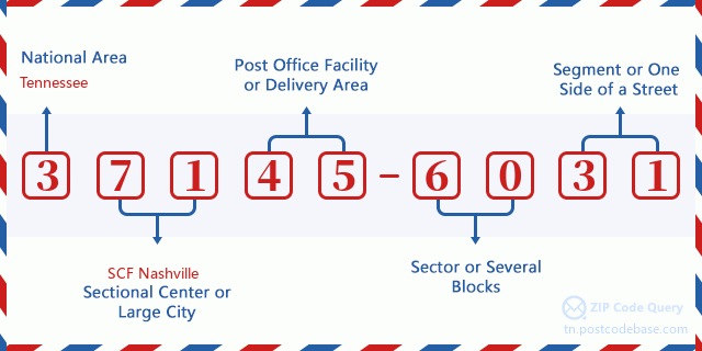

- ·Carrier Route ID?
A 4-digit code assigned to a mail delivery or collection route within a 5-digit ZIP Code. The first character of this identification is alphabetical, and the last three are numeric: Bnnn = PO box Hnnn = Highway contract Rnnn = Rural route Cnnn = City delivery Gnnn = General delivery: R002 (Rural route)
- ·ZIP Add-On Low Sector?
The ZIP Add-On Low Sector and the ZIP Add-On Low Segment together form the ZIP Add-On Low Number. The ZIP Add-On Low Number is the last four positions of a ZIP+4 code; the low-end ZIP add-on in a range of codes; the add-on of the first ZIP+4 code in a consecutive series of ZIP+4 codes assigned to the delivery address. For example, most delivery addresses are assigned a single ZIP+4 code. However, large companies may be given a range of ZIP+4 codes that can be used to route mail to specific departments. A range of ZIP+4 codes can also be assigned to a corresponding range of post office boxes, and each box is mapped, one-to-one, with a ZIP+4 code in the range. A single post office box can also be assigned a range of ZIP+4 codes.: 60
- ·ZIP Add-On Low Segment?
The ZIP Add-On Low Sector and the ZIP Add-On Low Segment together form the ZIP Add-On Low Number. The ZIP Add-On Low Number is the last four positions of a ZIP+4 code; the low-end ZIP add-on in a range of codes; the add-on of the first ZIP+4 code in a consecutive series of ZIP+4 codes assigned to the delivery address. For example, most delivery addresses are assigned a single ZIP+4 code. However, large companies may be given a range of ZIP+4 codes that can be used to route mail to specific departments. A range of ZIP+4 codes can also be assigned to a corresponding range of post office boxes, and each box is mapped, one-to-one, with a ZIP+4 code in the range. A single post office box can also be assigned a range of ZIP+4 codes.: 31
- ·ZIP Add-On High Sector?
The ZIP Add-On High Sector and the ZIP Add-On High Segment together form the ZIP Add-On High Number, which is the high-end ZIP add-on in a range of codes; the add-on of the last ZIP+4 code in a consecutive series of ZIP+4 codes assigned to the delivery address. Most delivery addresses are assigned a single ZIP+4 code; however, large companies may be given a range of ZIP+4 codes that can be used to route mail to specific departments. A range of ZIP+4 codes can also be assigned to a corresponding range of post office boxes, and each box is mapped, one-to-one, with a ZIP+4 code in the range. A single post office box can also be assigned a range of ZIP+4 codes. (See also ZIP Add-On Code.): 60
- ·ZIP Add-On High Segment?
The ZIP Add-On High Sector and the ZIP Add-On High Segment together form the ZIP Add-On High Number, which is the high-end ZIP add-on in a range of codes; the add-on of the last ZIP+4 code in a consecutive series of ZIP+4 codes assigned to the delivery address. Most delivery addresses are assigned a single ZIP+4 code; however, large companies may be given a range of ZIP+4 codes that can be used to route mail to specific departments. A range of ZIP+4 codes can also be assigned to a corresponding range of post office boxes, and each box is mapped, one-to-one, with a ZIP+4 code in the range. A single post office box can also be assigned a range of ZIP+4 codes. (See also ZIP Add-On Code.): 31
- ·ZIP Code Add On: 6031
- ·Range?
The range of +4 codes. Summing the +4 Code and the +4 Range will give you the high end of the range of +4 Codes that pertain to this ZIP Code.: 0
- ·Base Alternate Code?
Code that specifies whether a record is a base (preferred) or alternate record. Base records (represented as "B") can represent a range of addresses or an individual address, such as a firm record, while alternate records (represented as "A") are individual delivery points. Government deliveries will only be listed on alternate records with the appropriate government building indicator (federal, state, or city) set.: Base
- ·Finance Number?
A code assigned to Postal Service facilities (primarily post offices) to collect cost and statistical data and compile revenue and expense data. The state number comprises the first two positions of the finance number.: 476876
- ·Congressional District Number?
A standard value identifying a geographic area within the United States served by a member of the US House of Representatives or Senate. If Army/Air Force (APO) or fleet post office (FPO), this column will be blank. If there is only one member of Congress within a state, the code will be "AL" (at large).: 06
- ·Preferred Last Line City State Key?
An index to the City State file that provides the preferred last-line name for this address range.: X25658
Online Map

This is online map of the address 898 WARTRACE HWY, PLEASANT SHADE. You may use button to move and zoom in / out. The map information is for reference only.
Address: 898 (From 898 To 1198 Even) WARTRACE HWY, PLEASANT SHADE, TN 37145-6031, USA
Comment


Add new comment