نشانی: 5700 (From 5700 To 5898 Even) ROCKEY RD, ADAMS, TN 37010-4706, USA
؟37010-4706 چیست 37010-4706 یک کد فشرده 5 به همراه 4 عدد از 5700 (From 5700 To 5898 Even) ROCKEY RD, ADAMS, TN, USA است. اطلاعات بیشتر در زیر آمده است.
37010-4706 اطلاعات اولیه

-
کد پستی 5 به علاوه 4:
37010-4706 -
کد پستی 5:
37010 -
به علاوه 4?47064-digits that are used to identify a geographic segment within the 5-digit delivery area, such as a city block or a group of apartments or an individual high-volume receiver of mail, or any other unit that could use an extra identifier to aid in efficient mail sorting and delivery. This code is the low end of the range of +4 Codes that pertain to this ZIP Code. ZIP+4 Codes associated with nondelivery areas are composed of valid ZIP sector numbers and "ND" for the ZIP segment number, for example 12345-12ND. Non-deliverable areas are areas to which the USPS does not deliver mail, such as vacant lots and land that borders railroad tracks. Mailers should not match an address identified as a nondelivery area. If you absolutely must have numeric characters in the Plus4Code column, you may treat "ND" values as "00" (zero zero).:
-
کشور:
U.S. - ایالات متحده -
دولت:
TN - تنسی -
شهرستان:
CountyFIPS: 47147 - Robertson County -
شهر:
ADAMS -
خیابان?ROCKEY RDThe official name of a street as assigned by a local governing authority. The Street Name column contains only the street name and does not include directionals (EAST, WEST, etc.) or suffixes (ST, DR, BLVD, etc.). This element may also contain literals, such as PO BOX, GENERAL DELIVERY, USS, PSC, or UNIT. Numeric street names that have numeric components that are four characters (or less) in length at are justified such that the low-order digit of the number is positioned in the fourth position of the street name column. This shift is made so that the numeric street names appear in numeric sequence.:
-
پسوند خیابان?RD (جاده)The street suffix: For Example: ST = Street RD = Road DR = Drive LN = Lane:
-
نوع ثبت?S: خیابانAn alphabetic value that identifies the type of data in the record. Record type codes include the following: G = General delivery H = Highrise F = Firm S = Street P = PO box R = Rural route/highway contract:
نشانی

- شماره پایین آدرس اولیه?
A house, rural route, highway contract box, or post office box number; the numeric or alphanumeric component of an address preceding the street name; the low-end address in a range of addresses. Often referred to as house number.: 5700
- شماره بالا آدرس اولیه?
A house, rural route, contract box, or Post Office box number. The numeric or alphanumeric component of an address preceding the street name. The high-end address in a range of addresses. Often referred to as house number.: 5898
- کد فرد/ زوج آدرس اولیه?
Code that identifies the side or sides of a street for which a given address range is applicable. For street, highrise, firm and multi-carrier records, B = Both sides of a street, E = Even side of a street (even-numbered addresses in the range); O = Odd side of a street (odd-numbered addresses in the range). For general delivery, post office box, and rural route/highway contract records, this code will always be "B" (both).: Even
- اولیه محدوده: 5700, 5702, 5704, 5706, 5708, 5710, 5712, 5714, 5716, 5718, 5720, 5722, 5724, 5726, 5728, 5730, 5732, 5734, 5736, 5738, 5740, 5742, 5744, 5746, 5748, 5750, 5752, 5754, 5756, 5758, 5760, 5762, 5764, 5766, 5768, 5770, 5772, 5774, 5776, 5778, 5780, 5782, 5784, 5786, 5788, 5790, 5792, 5794, 5796, 5798, 5800, 5802, 5804, 5806, 5808, 5810, 5812, 5814, 5816, 5818, 5820, 5822, 5824, 5826, 5828, 5830, 5832, 5834, 5836, 5838, 5840, 5842, 5844, 5846, 5848, 5850, 5852, 5854, 5856, 5858, 5860, 5862, 5864, 5866, 5868, 5870, 5872, 5874, 5876, 5878, 5880, 5882, 5884, 5886, 5888, 5890, 5892, 5894, 5896, 5898.
لطفاً برای مشاهده کل لیست ، بر روی "نمونه های آدرس بیشتر" کلیک کنید.
5700 ROCKEY RD, ADAMS, TN 37010-4706
5702 ROCKEY RD, ADAMS, TN 37010-4706
5704 ROCKEY RD, ADAMS, TN 37010-4706
5706 ROCKEY RD, ADAMS, TN 37010-4706
5708 ROCKEY RD, ADAMS, TN 37010-4706
5710 ROCKEY RD, ADAMS, TN 37010-4706
5712 ROCKEY RD, ADAMS, TN 37010-4706
5714 ROCKEY RD, ADAMS, TN 37010-4706
5716 ROCKEY RD, ADAMS, TN 37010-4706
5718 ROCKEY RD, ADAMS, TN 37010-4706
5720 ROCKEY RD, ADAMS, TN 37010-4706
5722 ROCKEY RD, ADAMS, TN 37010-4706
5724 ROCKEY RD, ADAMS, TN 37010-4706
5726 ROCKEY RD, ADAMS, TN 37010-4706
5728 ROCKEY RD, ADAMS, TN 37010-4706
5730 ROCKEY RD, ADAMS, TN 37010-4706
5732 ROCKEY RD, ADAMS, TN 37010-4706
5734 ROCKEY RD, ADAMS, TN 37010-4706
5736 ROCKEY RD, ADAMS, TN 37010-4706
5738 ROCKEY RD, ADAMS, TN 37010-4706
5740 ROCKEY RD, ADAMS, TN 37010-4706
5742 ROCKEY RD, ADAMS, TN 37010-4706
5744 ROCKEY RD, ADAMS, TN 37010-4706
5746 ROCKEY RD, ADAMS, TN 37010-4706
5748 ROCKEY RD, ADAMS, TN 37010-4706
5750 ROCKEY RD, ADAMS, TN 37010-4706
5752 ROCKEY RD, ADAMS, TN 37010-4706
5754 ROCKEY RD, ADAMS, TN 37010-4706
5756 ROCKEY RD, ADAMS, TN 37010-4706
5758 ROCKEY RD, ADAMS, TN 37010-4706
5760 ROCKEY RD, ADAMS, TN 37010-4706
5762 ROCKEY RD, ADAMS, TN 37010-4706
5764 ROCKEY RD, ADAMS, TN 37010-4706
5766 ROCKEY RD, ADAMS, TN 37010-4706
5768 ROCKEY RD, ADAMS, TN 37010-4706
5770 ROCKEY RD, ADAMS, TN 37010-4706
5772 ROCKEY RD, ADAMS, TN 37010-4706
5774 ROCKEY RD, ADAMS, TN 37010-4706
5776 ROCKEY RD, ADAMS, TN 37010-4706
5778 ROCKEY RD, ADAMS, TN 37010-4706
5780 ROCKEY RD, ADAMS, TN 37010-4706
5782 ROCKEY RD, ADAMS, TN 37010-4706
5784 ROCKEY RD, ADAMS, TN 37010-4706
5786 ROCKEY RD, ADAMS, TN 37010-4706
5788 ROCKEY RD, ADAMS, TN 37010-4706
5790 ROCKEY RD, ADAMS, TN 37010-4706
5792 ROCKEY RD, ADAMS, TN 37010-4706
5794 ROCKEY RD, ADAMS, TN 37010-4706
5796 ROCKEY RD, ADAMS, TN 37010-4706
5798 ROCKEY RD, ADAMS, TN 37010-4706
5800 ROCKEY RD, ADAMS, TN 37010-4706
5802 ROCKEY RD, ADAMS, TN 37010-4706
5804 ROCKEY RD, ADAMS, TN 37010-4706
5806 ROCKEY RD, ADAMS, TN 37010-4706
5808 ROCKEY RD, ADAMS, TN 37010-4706
5810 ROCKEY RD, ADAMS, TN 37010-4706
5812 ROCKEY RD, ADAMS, TN 37010-4706
5814 ROCKEY RD, ADAMS, TN 37010-4706
5816 ROCKEY RD, ADAMS, TN 37010-4706
5818 ROCKEY RD, ADAMS, TN 37010-4706
5820 ROCKEY RD, ADAMS, TN 37010-4706
5822 ROCKEY RD, ADAMS, TN 37010-4706
5824 ROCKEY RD, ADAMS, TN 37010-4706
5826 ROCKEY RD, ADAMS, TN 37010-4706
5828 ROCKEY RD, ADAMS, TN 37010-4706
5830 ROCKEY RD, ADAMS, TN 37010-4706
5832 ROCKEY RD, ADAMS, TN 37010-4706
5834 ROCKEY RD, ADAMS, TN 37010-4706
5836 ROCKEY RD, ADAMS, TN 37010-4706
5838 ROCKEY RD, ADAMS, TN 37010-4706
5840 ROCKEY RD, ADAMS, TN 37010-4706
5842 ROCKEY RD, ADAMS, TN 37010-4706
5844 ROCKEY RD, ADAMS, TN 37010-4706
5846 ROCKEY RD, ADAMS, TN 37010-4706
5848 ROCKEY RD, ADAMS, TN 37010-4706
5850 ROCKEY RD, ADAMS, TN 37010-4706
5852 ROCKEY RD, ADAMS, TN 37010-4706
5854 ROCKEY RD, ADAMS, TN 37010-4706
5856 ROCKEY RD, ADAMS, TN 37010-4706
5858 ROCKEY RD, ADAMS, TN 37010-4706
5860 ROCKEY RD, ADAMS, TN 37010-4706
5862 ROCKEY RD, ADAMS, TN 37010-4706
5864 ROCKEY RD, ADAMS, TN 37010-4706
5866 ROCKEY RD, ADAMS, TN 37010-4706
5868 ROCKEY RD, ADAMS, TN 37010-4706
5870 ROCKEY RD, ADAMS, TN 37010-4706
5872 ROCKEY RD, ADAMS, TN 37010-4706
5874 ROCKEY RD, ADAMS, TN 37010-4706
5876 ROCKEY RD, ADAMS, TN 37010-4706
5878 ROCKEY RD, ADAMS, TN 37010-4706
5880 ROCKEY RD, ADAMS, TN 37010-4706
5882 ROCKEY RD, ADAMS, TN 37010-4706
5884 ROCKEY RD, ADAMS, TN 37010-4706
5886 ROCKEY RD, ADAMS, TN 37010-4706
5888 ROCKEY RD, ADAMS, TN 37010-4706
5890 ROCKEY RD, ADAMS, TN 37010-4706
5892 ROCKEY RD, ADAMS, TN 37010-4706
5894 ROCKEY RD, ADAMS, TN 37010-4706
5896 ROCKEY RD, ADAMS, TN 37010-4706
5898 ROCKEY RD, ADAMS, TN 37010-4706
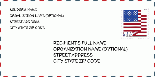
نشانی مثال
ADAMS TN 37010-4706
UNITED STATES OF AMERICA
37010-4706 نمونه پاکت

-
این نمونه ای از پاکت نامه ایالات متحده است. اطلاعات فرستنده را در بالا سمت چپ و اطلاعات گیرنده را در پایین سمت راست وارد کنید. اطلاعات لازم نام کامل فرستنده/گیرنده ، آدرس خیابان ، شهر ، ایالت و کد پستی است. اطلاعات آدرس گیرنده برای مرجع شما داده شده است. به طور کلی ، اگر از کد پستی کامل 9 رقمی مطمئن نیستید ، فقط می توانید کد پستی 5 رقمی را پر کنید تا از دست دادن بسته جلوگیری شود.
37010-4706 معنای اساسی
-
هر رقم کد پستی 37010-4706 مخفف چیست؟ کد ZIP+4 از دو بخش تشکیل شده است، پنج رقم اول را می توان در اداره پست قرار داد، و چهار رقم آخر می تواند یک بخش جغرافیایی را در منطقه تحویل پنج رقمی مشخص کند. 6-7 رقم بخش یا چند بلوک را مشخص می کند و رقم 8-9 نشان دهنده بخش یا یک طرف خیابان است.
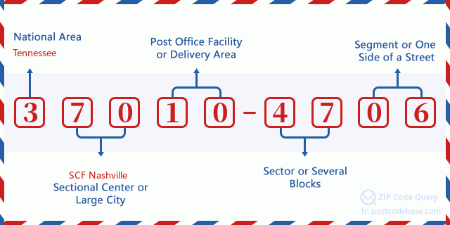

- ·شناسایی مسیر حامل?
A 4-digit code assigned to a mail delivery or collection route within a 5-digit ZIP Code. The first character of this identification is alphabetical, and the last three are numeric: Bnnn = PO box Hnnn = Highway contract Rnnn = Rural route Cnnn = City delivery Gnnn = General delivery: R002 (مسیر روستایی)
- ·بخش پایین افزونه فشرده?
The ZIP Add-On Low Sector and the ZIP Add-On Low Segment together form the ZIP Add-On Low Number. The ZIP Add-On Low Number is the last four positions of a ZIP+4 code; the low-end ZIP add-on in a range of codes; the add-on of the first ZIP+4 code in a consecutive series of ZIP+4 codes assigned to the delivery address. For example, most delivery addresses are assigned a single ZIP+4 code. However, large companies may be given a range of ZIP+4 codes that can be used to route mail to specific departments. A range of ZIP+4 codes can also be assigned to a corresponding range of post office boxes, and each box is mapped, one-to-one, with a ZIP+4 code in the range. A single post office box can also be assigned a range of ZIP+4 codes.: 47
- ·بخش پایین افزونه فشرده?
The ZIP Add-On Low Sector and the ZIP Add-On Low Segment together form the ZIP Add-On Low Number. The ZIP Add-On Low Number is the last four positions of a ZIP+4 code; the low-end ZIP add-on in a range of codes; the add-on of the first ZIP+4 code in a consecutive series of ZIP+4 codes assigned to the delivery address. For example, most delivery addresses are assigned a single ZIP+4 code. However, large companies may be given a range of ZIP+4 codes that can be used to route mail to specific departments. A range of ZIP+4 codes can also be assigned to a corresponding range of post office boxes, and each box is mapped, one-to-one, with a ZIP+4 code in the range. A single post office box can also be assigned a range of ZIP+4 codes.: 06
- ·بخش بالا افزونه فشرده?
The ZIP Add-On High Sector and the ZIP Add-On High Segment together form the ZIP Add-On High Number, which is the high-end ZIP add-on in a range of codes; the add-on of the last ZIP+4 code in a consecutive series of ZIP+4 codes assigned to the delivery address. Most delivery addresses are assigned a single ZIP+4 code; however, large companies may be given a range of ZIP+4 codes that can be used to route mail to specific departments. A range of ZIP+4 codes can also be assigned to a corresponding range of post office boxes, and each box is mapped, one-to-one, with a ZIP+4 code in the range. A single post office box can also be assigned a range of ZIP+4 codes. (See also ZIP Add-On Code.): 47
- ·بخش بالا افزونه فشرده?
The ZIP Add-On High Sector and the ZIP Add-On High Segment together form the ZIP Add-On High Number, which is the high-end ZIP add-on in a range of codes; the add-on of the last ZIP+4 code in a consecutive series of ZIP+4 codes assigned to the delivery address. Most delivery addresses are assigned a single ZIP+4 code; however, large companies may be given a range of ZIP+4 codes that can be used to route mail to specific departments. A range of ZIP+4 codes can also be assigned to a corresponding range of post office boxes, and each box is mapped, one-to-one, with a ZIP+4 code in the range. A single post office box can also be assigned a range of ZIP+4 codes. (See also ZIP Add-On Code.): 06
- ·کد پستی افزونه: 4706
- ·محدوده?
The range of +4 codes. Summing the +4 Code and the +4 Range will give you the high end of the range of +4 Codes that pertain to this ZIP Code.: 0
- ·کد متناوب پایه?
Code that specifies whether a record is a base (preferred) or alternate record. Base records (represented as "B") can represent a range of addresses or an individual address, such as a firm record, while alternate records (represented as "A") are individual delivery points. Government deliveries will only be listed on alternate records with the appropriate government building indicator (federal, state, or city) set.: پایه
- ·شماره مالی?
A code assigned to Postal Service facilities (primarily post offices) to collect cost and statistical data and compile revenue and expense data. The state number comprises the first two positions of the finance number.: 470024
- ·شماره ناحیه کنگره?
A standard value identifying a geographic area within the United States served by a member of the US House of Representatives or Senate. If Army/Air Force (APO) or fleet post office (FPO), this column will be blank. If there is only one member of Congress within a state, the code will be "AL" (at large).: 06
- ·کلید دولتی خط نهایی ترجیحی?
An index to the City State file that provides the preferred last-line name for this address range.: X24848
نقشه آنلاین

این نقشه آنلاین آدرس 5700 ROCKEY RD, ADAMS است. برای حرکت و زوم میتوانید از دکمه استفاده کنید. اطلاعات نقشه تنها برای مرجع است.
نشانی: 5700 (From 5700 To 5898 Even) ROCKEY RD, ADAMS, TN 37010-4706, USA
دیدگاه


افزودن دیدگاه جدید